


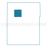
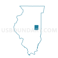
CONDIT Voting District, Champaign County, Illinois
About
Outline

Summary
| Unique Area Identifier | 564788 |
| Name | CONDIT Voting District |
| County | Champaign County |
| State | Illinois |
| Area (square miles) | 36.48 |
| Land Area (square miles) | 36.43 |
| Water Area (square miles) | 0.04 |
| % of Land Area | 99.88 |
| % of Water Area | 0.12 |
| Latitude of the Internal Point | 40.25650970 |
| Longtitude of the Internal Point | -88.27979940 |
Maps

Graphs
Select a template below for downloading or customizing gragh for CONDIT Voting District, Champaign County, Illinois


Neighbors
Neighoring Voting District (by Name) Neighboring Voting District on the Map
- BROWN-FISHER Voting District, Champaign County, IL
- EAST BEND Voting District, Champaign County, IL
- HENSLEY Voting District, Champaign County, IL
- LUDLOW 2 Voting District, Champaign County, IL
- NEWCOMB Voting District, Champaign County, IL
- RANTOUL 1 Voting District, Champaign County, IL
- RANTOUL 4 Voting District, Champaign County, IL
- SOMER Voting District, Champaign County, IL
Top 10 Neighboring County Subdivision (by Population) Neighboring County Subdivision on the Map
- Rantoul township, Champaign County, IL (11,273)
- Ludlow township, Champaign County, IL (4,278)
- Brown township, Champaign County, IL (1,995)
- Newcomb township, Champaign County, IL (1,292)
- Hensley township, Champaign County, IL (1,278)
- Somer township, Champaign County, IL (1,268)
- East Bend township, Champaign County, IL (584)
- Condit township, Champaign County, IL (500)
Top 10 Neighboring Place (by Population) Neighboring Place on the Map
Top 10 Neighboring Elementary School District (by Population) Neighboring Elementary School District on the Map
- Rantoul City School District 137, IL (12,520)
- Thomasboro Community Consolidated School District 130, IL (2,443)
Top 10 Neighboring Secondary School District (by Population) Neighboring Secondary School District on the Map
Top 10 Neighboring Unified School District (by Population) Neighboring Unified School District on the Map
- Champaign Community Unit School District 4, IL (93,268)
- Mahomet-Seymour Community Unit School District 3, IL (14,300)
- Fisher Community Unit School District 1, IL (3,246)
Top 10 Neighboring State Legislative District Lower Chamber (by Population) Neighboring State Legislative District Lower Chamber on the Map
Top 10 Neighboring State Legislative District Upper Chamber (by Population) Neighboring State Legislative District Upper Chamber on the Map
Top 10 Neighboring 111th Congressional District (by Population) Neighboring 111th Congressional District on the Map
Top 10 Neighboring Census Tract (by Population) Neighboring Census Tract on the Map
- Census Tract 106.03, Champaign County, IL (7,144)
- Census Tract 104, Champaign County, IL (4,809)
- Census Tract 105, Champaign County, IL (4,371)
- Census Tract 106.04, Champaign County, IL (3,151)
Top 10 Neighboring 5-Digit ZIP Code Tabulation Area (by Population) Neighboring 5-Digit ZIP Code Tabulation Area on the Map
- 61822, IL (21,608)
- 61866, IL (14,048)
- 61853, IL (13,206)
- 61843, IL (2,363)
- 61878, IL (1,433)
- 61840, IL (709)